
weetwood south
Character of the area
The southern part of Weetwood Lane is generally more built-up than the northern part, though it still presents a landscape-dominated character. Although the nineteenth century stone and brick development emanating from Far Headingley proper began the process of development here stone buildings at Weetwood Lane Farm and on Weetwood Mill Lane are reminders of an earlier agricultural and industrial era. The southern part of Weetwood Lane is fairly wide with generous grass verges, before it narrows round the tight bend to the north.
Where the earlier villa properties were built in stone, the 1920/30s houses in the Hollins are mainly wellproportioned semi-detached two storey family houses, largely rendered with some stone facings; roofs are gabled with generous eaves and red Rosemary tiles (many sadly replaced with concrete). Because of thetopography, many properties have a steep slope either front-to-back or side-to-side, giving interesting elevations and aspects. Some have been sensitively extended and more have roof lights added: there are some dormers, but these generally do not fit in well with the style of building.
Everywhere there are trees: sometimes planted in verges, most often in the generous gardens. Boundaries to the street are various species of hedges or hedges above low gritstone or brick walls. The older gritstone walls with semi-circular cappings, which line most of Weetwood Lane as well as the south side of Hollin Lane and the boundary to Meanwood Park, are a particularly important feature in the street scene. Many of the streets also have gritstone kerbs – some unfortunately replaced by concrete.
While Otley Road to the west is the main north/south route for traffic, Weetwood Lane provides a secondary route through the centre of the area. Glen Road connecting these two routes is subject to severe rush hour congestion and day-long parking in connection with commuting and the Leeds Met University campus opposite. Richmond House School on Otley Road now has dedicated parking and set-down/pick-up areas, accessed from Glen Road, which have reduced, but not eliminated, that contribution to congestion.
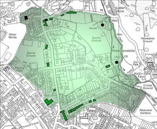
Though on the edge, the Meanwood Valley is an important feature of the area and Meanwoodside, connecting with the grounds of the Hollies, is publicly owned and accessible with a variety of flora and fauna. Owing to the topography, access across Meanwood Beck is only by foot or cycle paths; it is absolutely essential for the character of the area that this is never changed. Currently, the broader parts of the valley floor are given over to recreation (municipal parkland, sports grounds and allotments), and there is a large and well-valued sports field on the upper level (Glen Road).
There is a very wide range of accommodation in this small area which enables people to move to suitable accommodation as their needs change during their lifetime, but to remain within the local area. It is hoped that the recent controls over conversions to houses in multiple occupation will reduce a trend which causes concerns that the character of the the area and its quality of environment may be adversely affected. As it is, the area is known to be a very desirable area in which to live, bring up a family and spend retirement and the population is therefore very stable.
Key positive characteristics
• Variety and quality of both built and natural environment in a small area
• General feeling of spaciousness and calm
• Variety and prevalence of pleasing views and vistas throughout
• Private and public open spaces including wide verges and green areas within highway land, providing green lungs locally and for the City in general
• Wealth of mature and specimen trees, with associated greenery
• variety of hedgerow species providing colour contrast and variety throughout the year
• Wealth of ancient features: stone boundary walls and buildings
• Wealth of footpaths and bridleways through the area and connecting to the City and countryside
• Very limited commercial activity
Extracted from Far Headingley, Weetwood & West Park Neighbourhood Design Statement, Leeds City Council, 2ed, 2014. The whole document is available online at <http://www.leeds.gov.uk/docs/FH%20NDS%20Adoption%20Version.pdf>
See also, Listed Buildings. For the area now, go to Weetwood. For historic photographs of the area, go to Historic Weetwood. For a guided walk, go to Wandering through Weetwood.
